MavicPro Drone Mapping
MavicPro with DroneDeploy autonomous flight control app
MavicPro Drone Mapping
DroneAce recently tested the DJI MavicPro drone mapping capabilities using DroneDeploy as the autonomous flight control platform. An aerial survey was undertaken of a quarry in Brisbane, the data then processed and analyzed using photogrammetry software and exported for further use in GIS.
Simplified Drone Mapping Workflow
Unmanned Aerial Vehicles (UAV’s) have introduced new efficiencies and cost savings into aerial mapping allowing various stakeholders access to high resolution multi format GIS data for further visualisation, analysis and interpretation purposes all with a rapid turn-around time. Using drones is often safer and is a fraction of the cost of traditional manned flights. Drone mapping consists of flight planning and mission uploading, drone flying and capture of images and finally the processing of data & distribution of information
Plan & Load Flight Mission

Fly & Capture Images

Process Data & Provide Information

Drone Mapping Pre-Flight
Identify area of interest for drone mapping
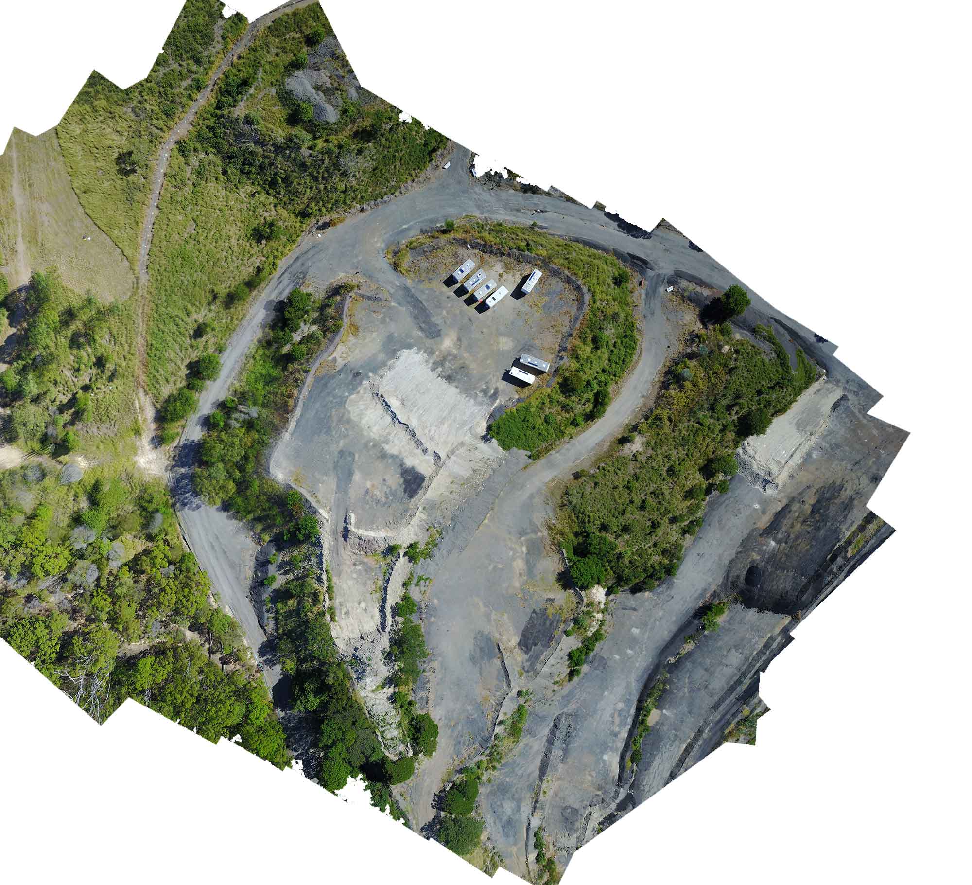
Using Google Earth Pro we identified White Hill Quarry as a potential site to test the MavicPro drone mapping capabilities as it was in a fairly isolated environment, there was public access to a suitable launch/landing site nearby that also provided the opportunity for an essential site visit.
Using Google Earth Pro we were able to get a rough estimate of the terrain profile and although the quarry is extensive, decided to drone map only a small portion adjacent to the launch point.


Drone Mapping Site Inspection
A site inspection prior to the drone mapping flight was crucial to identify any natural or purpose built structures that may interfere with the operation of the drone on the day of flight such as large trees, communication towers, power lines and exhaust stacks. At the Whites Hill quarry, a suitable launch / landing site was identified that would provide an unobstructed view to the drone at all times ensuring CASA compliance of maintaining visual line of site (VLOS) at all times.

DroneDeploy for Autonomous Drone Mapping with the MavicPro
Flight planning and image acquisition plan
We used DroneDeploy as the autonomous drone mapping control system, accessing the web based service via a desktop PC and immediately loading the planned flight onto an Ipad for later use on location. Creating a new mission was simple with a new mission plan bringing up satellite imagery of the area to be mapped with an superimposed vector based flight plan that can be adjusted to suit.
Flight planning for image quality was unnecessary as there were no specific requirements for the ground sampling distance GSD with the default DroneDeploy setting used with the exception of the Flight Direction parameter adjusted to minimize flight time and the Automatic Camera Settings set to off.
• Flight time: 2.48 minutes
• Mapping Area: 2 hectares
• GSD: 3.2 cm/pixel
• Altitude: 75m
• Sidelap: 70%
• Frontlap: 60%
• Max Flight speed: 15m/s
MavicPro Camera Specifications
MavicPro uses the 12 megapixel 12bit Sony IMx377 sensor with a camera focal length of 28mm, 78 degrees FOV and a constant aperture of f2.2.

Drone Mapping Data Capture
Before any drone mapping could take place, it was essential to undertake pre-flight checklists to ensure a safe and successful outcome.
MavicPro Preflight checklists
The MavicPro drone mapping sequence was monitored using an Ipad. The version of DroneDeploy was 0.063-2.0.21 and the DJI G04 (app version 4.04) firmware Version was 01.03.0500. We ran through the MavicPro status using the DJI Go 4 app, checking the strength of GPS, the return to height was set appropriately then closed the app and ran DroneDeploy selecting the appropriate mission.
While all items in the pre-flight checklist where important, we paid special attention to 100% UAV drone flight battery, 100% remote controller battery, 100% IPad battery and the Home Point had been set.
MavicPro Camera Setup to Improve Drone Mapping Data
As the aerial photographs captured were to be processed using photogrammetry techniques, it was important to have optimum camera settings for maximum image quality. The shutter speed was set to manual and adjusted pre-flight to ensure correct exposure.
• Shutter speed: 1/690 sec (must be high enough to ensure no blurred images)
• ISO : 100 (set as low as possible to minimise noise)
• White balance: manual – sunny (set based on current conditions)
• Focus: automatic (The focus was set to automatic however can be set to manual at the hyperfocal distance of 13m prior to flight)

Drone Mapping and Situational Awareness
One of the more important tasks for a drone pilot undertaking drone mapping is to maintain a consistent awareness of what is happening in the immediate surrounds.
During the drone mapping data capture phase, it is vital to maintain situational awareness of your surrounds, and observe any changes in the weather conditions on all sides and make sure the telemetry on the hand controller is constantly monitored including drone battery reserves , hand controller battery reserves and GPS signal strength. This includes maintain vigilance with respect to any people or animals that may enter the vicinity of the flight control area, which is especially important during the landing phase.
Time of Flight
The time of flight was just under 3 minutes with the MavicPro capturing 46 aerial photographs . After the final image was captured the camera returned to the forward facing position ensuring the lens was not scratched when landing.
Upon finishing the mapping mission in DroneDeploy, the MavicPro automatically returned to a position 75 metres above the home point. At this stage we took manual control of the drone to ensure it landed safety.
No GCP ‘s where recorded on location due to restricted public access and with the main purpose of the drone mapping mission being familiarisation of the DroneDeploy app.
Processing Drone Mapping Data Using Photogrammetry
Although DroneDeploy offer a rapid and affordable cloud based processing & analysis service, the drone mapping images where processed using photogrammetry software by Pix4D allowing for the generation of a high-resolution orthomosaic, a 3D coloured point cloud, DEM (digital elevation model) and a 3D mesh model.
Deliverables for quarries and mines – turning drone data into actionable information
Multiple information can be acquired after the initial UAV drone capture and processing phase. These include
• Volumetric stock pile calculations
• Visual site inspections
• Contours generation
• Profiling
• Height pile monitoring
Point Cloud Data
Point clouds are 3 dimensional data files consisting of just that, clouds of points that represent surfaces in the physical world. Point clouds saved in public domain file formats such as LAS files benefit from having the ability to be opened in third party GIS and 3D software such as PointCAB, ArcGIS and AutoCAD Map 3D for further analysis and processing. The point cloud generated from the MavicPro drone mapping run and subsequent photogrammetry process has 75 million points.
Point cloud file with 75 million points

Orthomosaics
Orthomosaics or orthophotos are geospatially correct aerial images (orthorectified) such that the scale across the photograph is unifoprm.They can be used to measure true distance as they are an accurate representation of the earths surface having being compensated for lens distortion and camera tilt.
High resolution orthomosaic 10760 by 9791 pixels with a GSP of 2.7cm/pixel

Orthomosaic at 100%, note the containers have no depth

Stitching vs Orthorectification
Stitching to produce a composite image using Autopano Giga resulted in photo mismatch and therefore not suitable for measurements. Creating an orthomosaic that uses orthorectification that removes perspective distortion and provides accurate scale and position.
Mouse over the image to switch from stitched to orthorectified

DEM
A Digital Elevation Model (DEM) is used to create an orthophoto, the orthophoto then being used in a Graphic Information System (GIS) as a “map accurate” background image. The DEM created in this instance was 14415 by 13585 pixels with a GSD of 2.7cm/pixel

3D Model
Point Clouds can be converted into a 3D mesh which are files that depicts spatial information as geometry made up of faces and polygons, rather than points. Meshes generally have lower resolution and size and are hence easier to navigate and manipulate on a computer.

Benefits of Using UAVs for Drone Mapping
Using low cost UAV’s such as the MavicPro for drone mapping platforms opens up a range of possibilities for drone service providers to help quarries and mines that require quick and accurate surveying to measure and monitor ground terrain changes and create highly accurate volumetric analysis. The cost savings for survey projects using aerial drones instead of ground based techniques can be substantial with the added benefit of increased safety for surveyors, a faster turn around time and minimal disruption to the site
Using autonomous flight control apps provide for accurate and custom target drone mapping areas editable minutes before flight time and allow for accurately repeatable flight missions.
The data set of 46 aerial images is available for download.